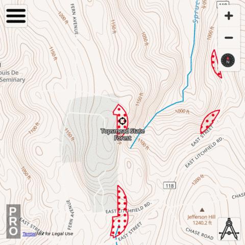
i-Hunting app includes Area Closed 500 Foot Boundary hunt layer under Connecticut -> Area Closed 500 Foot Boundary. To enable this layer, please use the following taps:
|
|
Available Attributes for Area Closed 500 Foot Boundary , Connecticut
- Name
Available Area Closed 500 Foot Boundary
- Aldo Leopold WMA
- Algonguin State Forest
- American Legion State Forest
- Assekonk Swamp WMA
- Babcock Pond WMA
- Barn Island WMA
- Bartlett Brook WMA
- Bear Hill WMA
- Beaver Brook State Park
- Bishops Swamp WMA
- Black Pond WMA
- Black Rock Lake State Park
- Bloomfield Flood Control Site 1
- Bloomfield Flood Control Site 1
- Bloomfield Flood Control Site 2
- Bolton Permit-Required Area
- Bristol Water Company
- Camp Columbia State Forest
- Cedar Swamp WMA
- Centennial Watershed State Forest (Deer Lottery Area)
- Centennial Watershed State Forest - Monroe Parcel (Garder Road)
- Centennial Watershed State Forest - Shelton Parcel
- Cockaponset State Forest
- Cromwell Meadows WMA
- Cromwell Meadows WMA
- Durham Meadows WMA
- East River Marsh WMA
- East Swamp WMA
- East Twin Lakes Water Access Area
- East Twin Lakes Water Access Area
- East Windsor / Enfield Permit Required Area
- Eightmile River WMA
- Eightmile River WMA
- Ellithorpe Flood Control Area
- Enders State Forest
- Flaherty Field Trial Area
- Franklin Swamp WMA
- Goshen WMA
- Great Harbor WMA
- Great Swamp Flood Control Area
- Hancock Brook Lake
- Hebron Permit Required Area
- Higganum-Haddam Rod & Gun Club
- Housatonic State Forest
- John A. Minetto State Park
- Killingly Pond State Park
- Kollar WMA
- Larson Lot WMA
- Little River Fish and Wildlife Area
- Mad River Dam Flood Control Area
- Mattatuck State Forest
- MDC Colebrook Reservoir / Hogback Dam
- MDC Greenwoods Pond
- Meadow Brook WMA
- Meriden Rod & Gun Club
- Meshomasic State Forest
- Meshomasic State Forest
- Messerschmidt WMA
- Millers Pond
- Mohawk State Forest - Ziegler/Johnson Tract
- Mohegan State Forest
- Nassahegon State Forest
- Natchaug State Forest
- Nathan Hale State Forest
- Naugatuck State Forest
- Naugatuck State Forest
- Nehantic State Forest
- Nepaug State Forest
- Newgate WMA
- Newgate WMA
- Newgate WMA
- Newgate WMA
- Newgate WMA
- Nipmuck State Forest
- Nod Brook Wildlife Area
- Norwich PR 500FT
- NU Maromas Coop WMA
- NU Skiff Mountain Coop WMA
- Nye Holman State Forest
- Pachaug State Forest
- Paugnut State Forest
- Paugussett State Forest
- Pease Brook WMA
- Peoples State Forest
- Pequonnock Valley Permit-Required Area
- Pootatuck State Forest
- Quaddick State Forest
- Quaddick State Forest
- Quinebaug River WMA
- Quinnipiac River Marsh WMA
- Quinnipiac River State Park
- Ragged Rock Creek WMA
- Raymond Brook Marsh
- Red Cedar Lake (Camp Mooween)
- Robbins Swamp WMA
- Roger Tory Peterson WMA
- Roraback WMA
- Rose Hill WMA
- Rose Hill WMA
- Rose Hill WMA
- Ross Marsh WMA
- Salmon River State Forest
- Salmon River State Forest
- Salmon River State Forest
- Scantic River SP & East Windsor/Enfield PR Area
- Scantic River State Park
- Selden Neck State Park
- Sessions Woods WMA
- Seymour-Oxford Permit-Required
- Seymour-Oxford Permit-Required
- Shenipsit State Forest
- Shenipsit State Forest
- Silvio O. Conte NWR Salmon River Division
- Simsbury WMA
- South Cove Wildlife Area
- Spignesi WMA
- Spignesi WMA
- Sprague PR Area
- Stanley Works Coop WMA
- Sucker Brook Flood Control Area
- Suffield Sportsmen's Association
- Suffield WMA
- Sunny Brook State Park
- Talbot WMA
- Tankerhoosen WMA
- Topsmead State Forest
- Trout Brook Valley
- Tunxis State Forest
- Tunxis State Forest
- Wallingford Town Owned Area
- Wangunk Meadows WMA
- West Thompson Dam
- Whiting River Flood Control Area
- Wood Creek Flood Control Area
- Wood Creek Flood Control Wood Creek Flood Control Area
- Woodstock Permit-Required
- Woodstock Permit-Required
- Wooster Mountain State Park
- Wopowog WMA
- Wyantenock State Forest
- Yale Forest
- Zemko Pond WMA

